
Marathon
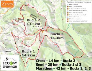 Marathon (B1, B2, B3): approximately 42km, 2150m positive/ negative gain, 9h time limit
Semi (B1, B3) :approximately 28KM, 1400m D+ * special distance in 2026
The Marathon course is made out of 3 loops forming the EcoRun Moieciu clover, the Start and the Finish are in Moieciu de Sus. Semi route is representing only part of the marathon – B1 and B3 loops.
Course description for Marathon (Semi only B1 &B3):
1st Loop: approx. 14.2 km
START – Moieciu de Sus – La Mandru – Fundata – Moieciu de Sus: around 14,2 km
The START of the Cross is from the centre of Moieciu de Sus, in front of the House of Culture. The first loop follows the asphalt on the “Valea Popii” and continues 1km on the country-road.
The trail crosses the river on a wooden bridge on the right side of the valley and covers the steep slope ascending trough the forest „La Mandru” where is the first hydration point (only water). After another 700m of smooth ascent the course suddenly turns right following a marked trail (country road – red line) going down from “Muntele Sf. Ilie” to Fundatica Village in Valea Cheii.
From here the course continues right on the road and then leave immediately on the left side with a short but sustained climb, and after another 1.5km of alternate short ascends the course reaches CP1, a refreshment check point with energy beverages and food. From here the course continues 800m on the paved road and then turns right on a small alley between the houses and get back into another dirt road.
After a few hundred meters the last ascent of Loop 1 begins going to a boundary road. From here the trail descends gently at first and then more steeply to the Moieciu de Sus along a George’s path.
The last part of descent is quite steep and the path should be followed exactly without stepping outside it, to avoid damage to the meadow.
The last meters takes you to EcoKids Route and will follow a path to avoid the asphalt, will reach the telecommunication site and come down on the path from behind The Church to reach Moieciu de Sus in the central point (CP2), which marks the arrival of the competitor at the End of the 1st Loop of the Marathon race.
Here will be the first time barrier – 2.30 hours from start time.
2nd Loop: approx. 13,5km
Moieciu de Sus -> Culmea Lunga -> Valea Lunga -> Cheile Gradistei – Moieciu -> Cheile Gradistei – Fundata -> Moieciu de Sus
The course continues the ascent beside the school in Moieciu de Sus. The ascent is almost 1.3 km long and has a positive gain of 240m. On this part of the race the track is narrow and it is bordered by several fences. On rainy days, the path becomes very slippery and muddy and makes it difficult to run. This ascent ends at an altitude of about 1200m near ‘Zilistea’ Corner, at the 15,5km mark of the race; after this ascent, the course follows a 2 km rather flat trail along ‘Culmea Lunga’ ridge. From here the course descends steeply to ‘Cheile Gradistei – Moieciu’ Resort. On this part of the course it is mandatory to follow up exactly the trail to avoid damaging the meadows.
From ‘Cheile Gradistei – Moieciu’ Resort (which is a hydration point located on the teahouse) the route ascends the short ski slope, then turns left and climbs near the ski cable pole in the forest. The course smoothly follows a forest road and then enters a path and after a sustained climb the course reaches a clearing where the participants might be checked. Then the course goes left and easily ascends on a stony road and after two rows of large coils the course gets out in a clearing, check point and refreshment point at this moment – near the Resort. From here the course goes inside the sport area for a loop. After 2,5 kms you will follow a well defined road leading to the church in Fundata Village.
From here the route descends on a road on the left and then a visible trail in Moieciu de Sus, passes by the antenna and the church from Moieciu de Sus and then reaches the central point again, CP4, the final point on 2nd Loop on a narrow path. Here will be the second time barrier – 6 hours from the start time.
3rd Loop: approx. 14,3km
Moieciu de Sus -> La Bisericuta -> Valea Bangaleasa -> Poiana Gutanu -> Poiana Plesii -> Moieciu de Sus -> FINISH
Here is the 29th Km – the course starts on the ‘Valea Popii’ and after 950m ascends on the left side of the valley to ‘Bisericuta’ peak, a 320m ascent. The ascent is at first steep and after the first 500m the slope becomes easier. The course then follows a undulating trail along “Bisericutei Hill” until a path junction marked by a wooden cross, the beginning of a steep descent to ‘Bangaleasa’ Vally. Following Bangaleasa Valley on a forest road for 700m, the course reaches the last great ascent of the EcoRun Moieciu to “Gutanu” glade. After the refreshment point the course crosses the ‘Bangaleasa’ River, ascends trough the forest almost 360m positive gain until it reaches the highest point – 1460m, 34th km. The course reaches a clearing, where is the Check Point CP5. From here the course covers the last 6km along ‘Plesii’ Ridge.
The course follows the tourist trail marked with red stripe, which descends from ‘Bucegi’ Mountains and leads to ‘Simon’ village, until it reaches the junction and goes left to Moieciu de Sus. The course covers the ridge until over the center of Moieciu de Sus village, where the area opens and then descends steeply to Moieciu de Sus. The route crosses again Bangaleasa River and the last 300m of the race are on the asphalt road until it reaches the FINISH line.
(start), (checkpoint), (water), (food), (finish)
| Location | KM | Altitude | Elevation |
|---|---|---|---|
| Moieciu de Sus | 0.0 | 957 | |
| Bridge | 3.2 | 1080 | 123 |
| Mandru | 5.2 | 1372 | 292 |
| Intersecție Fundata-Fundatica | 7.0 | 1193 | -179 |
| Padina Lunga | 8.6 | 1202 | 9 |
| Scoala Fundata | 9.0 | 1305 | 103 |
| Intersecție | 11.0 | 1233 | -72 |
| Intersecție Poteca lui George | 11.8 | 1327 | 94 |
| Moieciu de Sus | 14.2 | 957 | -370 |
| Colțul Zilistea | 15.5 | 1200 | 243 |
| Culmea Lungă | 16.2 | 1150 | -50 |
| Vârful Cremenii | 16.8 | 1180 | 30 |
| Ch. Gradistei Moieciu de Jos | 18.8 | 881 | -299 |
| Resort Ch. Gradistei Fundata | 22,5 | 1300 | 419 |
| Biserica Fundata | 25.7 | 1200 | -100, +100 |
| Moieciu de Sus | 27.7 | 957 | -243 |
| La Bisericuta | 32 | 1283 | 326 |
| Valea Bangaleasa – Moieciu de Sus | 34.0 | 1096 | -187 |
| Poiana Guțanu | 35.8 | 1455 | 359 |
| Intersecție Moieciu – Simon | 39.7 | 1215 | -240 |
| Moieciu de Sus | 42 | 957 | -258 |